After 6 hours of work and 3 hours of sleep HERE'S MY SLIDE SHOW
Tuesday, March 3, 2009
Tuesday, February 24, 2009
This Old House
Well, my life isn't that exciting. But, everyone I know talks to me about where I live. Some people really like my house, some people hate my neighborhood. So i decided to document my house and the life i live inside of it.
Hopefully I figured out how to post my audio-slideshow or this is just a silly placeholder.
Stay Tuned!
update.
fail.
Hopefully I figured out how to post my audio-slideshow or this is just a silly placeholder.
Stay Tuned!
update.
fail.
Monday, February 16, 2009
Streets of Philadelphia (A to Z)
Believe it or not Philly has at least one street that starts with every letter of the alphabet. WILD! I tried to vary where I shot to all different parts of the city, North, South, Center and West. HOLLA!
View Larger Map

A is for Arch

B is for Berks

C is for Colona

D is for Dauphin

E is for Ellsworth

F is for Fairmount

G is for Green

H is for Harper
I is for Ionic (kind of just an alley)

J is for JFK

K is for Kelly Drive

L is for Liacouras

M is for Morris

N is for Norris

O is for Opal

P is for Poplar

Q is for Quince

R is for Ridge

S is for Susquehanna

T is for Thirteenth

U is for Uber

V is for Vine (express way)

W is for Washington

X IS FOR MS PAINT X-PLOSION! Yea... I could not find an X street.
View Larger Map

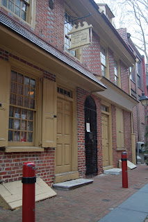


House on Elfreth's Alley. It clearly demonstrates the changes over time that happened in the neighborhood, even if they aren't very drastic and mostly cosmetic.


Another view looking East down Elfreth's Alley
View Larger Map

A is for Arch

B is for Berks

C is for Colona

D is for Dauphin

E is for Ellsworth

F is for Fairmount

G is for Green

H is for Harper
I is for Ionic (kind of just an alley)

J is for JFK

K is for Kelly Drive

L is for Liacouras

M is for Morris

N is for Norris

O is for Opal

P is for Poplar

Q is for Quince

R is for Ridge

S is for Susquehanna

T is for Thirteenth

U is for Uber

V is for Vine (express way)

W is for Washington

X IS FOR MS PAINT X-PLOSION! Yea... I could not find an X street.


Monday, February 9, 2009
Mapping Center City Philadelphia
For this project we had to map a street in Center City that went from river to river. I chose Market Street, and I decided on a theme that is very dear to me; public transportation. Due to my lack of a driver's license I rely on the services of SEPTA, PATCO, Greyhound, and other fine companies to get around from place to place. Without them id be stuck here in my room in North Philadelphia, or forced to walk or ride a bike far distaces. No thank you.
View Larger Map

Train tracks betweenthe PECO building and the Schuykill River.

Shot of 30th Street Station and the Cirra Center from 23rd street

22nd Street Trolley signpost with PECO building in the backround

Corner of 20th and Market

Bus Shelter on 19th Street

18th Street Trolley station.


15th Street exit for Blue, Orange, Green, Regional Rail, and PATCO lines.

City hall from a locked subway exit.

13th Street Station with City Hall and the new Ritz building.

Passengers waiting for the bus at 12 street station.

Market East Regional Rail Station at 11th Street

10th Street Subway entrance. PSFS building (now a hotel) in the backround

Bus shelter at 9th and Market

Entrance to 8th and Market PATCO / Subway station

Corner of 7th and Market, NJ Transit Bus shelter.

Fancy Cabs at 6th and Market. One day I'll be fancy enough. Maybe.

Subway exit at 5th and Market in disrepair.

Corner of 4th and Market

Bus Shelter and Lampost at 3rd and Market

2nd and Market Bus / Subway Station

Bus Terminal at Front and Market Streets.
View Larger Map

Train tracks betweenthe PECO building and the Schuykill River.

Shot of 30th Street Station and the Cirra Center from 23rd street

22nd Street Trolley signpost with PECO building in the backround

Corner of 20th and Market

Bus Shelter on 19th Street

18th Street Trolley station.

Buses at 17th Street.

Tags on 16th Street, next to Regional Rail exit.

15th Street exit for Blue, Orange, Green, Regional Rail, and PATCO lines.

City hall from a locked subway exit.

13th Street Station with City Hall and the new Ritz building.

Passengers waiting for the bus at 12 street station.

Market East Regional Rail Station at 11th Street

10th Street Subway entrance. PSFS building (now a hotel) in the backround

Bus shelter at 9th and Market

Entrance to 8th and Market PATCO / Subway station

Corner of 7th and Market, NJ Transit Bus shelter.

Fancy Cabs at 6th and Market. One day I'll be fancy enough. Maybe.

Subway exit at 5th and Market in disrepair.

Corner of 4th and Market

Bus Shelter and Lampost at 3rd and Market

2nd and Market Bus / Subway Station

Bus Terminal at Front and Market Streets.
Wednesday, January 28, 2009
Philadelphia Past and Present
View Larger Map


These houses on the Alley were converted into shops, none of the other houses have.


Full view of Elfreth's Alley looking East, notice the missing house on the right hand side.


View of the first few houses on the block, highlighting the missing house. This is the only part of the block where the original houses are missing.


View looking East on Elfreth's Alley


Several doors in a row on the Alley.


View of the last few houses on the block, looking East.


An even smaller alley next to 115 Elfreth's


Doors of 115 and the neighboring house.


View East on Elfreth's, highlighting cellar doors.


House on Elfreth's Alley. It clearly demonstrates the changes over time that happened in the neighborhood, even if they aren't very drastic and mostly cosmetic.

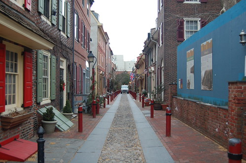
Another view looking East down Elfreth's Alley
Subscribe to:
Posts (Atom)